By Township Canada
AER CCS Pore Space Tenure: How to Identify Quarter Sections in Licensed Tenure Zones
How to identify which DLS quarter sections fall within AER-licensed CCS pore space tenure zones using Township Canada's CCS Tenure Layer and batch export.
You're preparing an AER pore space tenure proposal for a carbon capture and storage project. The geological assessment defines a subsurface formation boundary, a CO₂ storage target spanning multiple DLS townships. Before that formation boundary becomes an AER filing, you need a precise list of every quarter section that falls within or adjacent to the licensed tenure zone. And the AER CCS pore space tenure deadline is June 30, 2026.
The question sounds simple: which quarter sections are in this tenure zone? In practice, answering it requires cross-referencing a geological extent against the DLS survey grid, checking each parcel against existing tenure boundaries, and producing the GeoJSON or shapefile data the AER expects in the submission package. That workflow used to mean toggling between the AER's OneStop registry, a GIS application, and a spreadsheet. It doesn't have to.
What AER Pore Space Tenure Covers, and Why Quarter Sections Matter
Under Alberta's Carbon Sequestration Tenure Regulations, a pore space tenure licence grants the holder exclusive rights to use a subsurface geological formation for CO₂ storage. The AER defines the tenure area using DLS legal land descriptions: sections and quarter sections that map the horizontal extent of the approved storage zone.
A single CCS tenure zone typically spans 10 to 30 DLS sections across two or more townships. But the AER doesn't just want section-level descriptions. Surface infrastructure (injection wells, monitoring wells, compressor facilities, pipeline corridors) is described at the quarter section or LSD level. And when a tenure zone boundary cuts through a section rather than following a clean section line, the individual quarter sections that fall inside the boundary must be enumerated in the application.
That's where the practical difficulty sits. A tenure zone covering 20 DLS sections contains up to 320 quarter sections. Each one needs to be accounted for: is it fully inside the tenure boundary, partially overlapping, or adjacent? The answer determines what appears in the AER application and what lands in the supporting GeoJSON exhibit.
How Tenure Zone Boundaries Relate to the DLS Grid
A geological formation boundary follows subsurface geology: the edge of a deep saline aquifer or the extent of a depleted reservoir. The DLS survey grid follows surveyed township and section lines established in the 1880s. These two systems don't align.
Consider a proposed storage formation in the Fort Saskatchewan-Heartland industrial corridor, centred around Township 55, Range 20, West of the 4th Meridian. The geological model shows the target aquifer extending from Section 3 in the south to Section 34 in the north, and from Range 19 to Range 21. But the western edge of the formation cuts diagonally through several sections in Range 21, meaning some quarter sections in those sections are inside the storage target and others are not.
For each section where the boundary doesn't follow a clean line, you need to identify specifically which quarter sections (NE, NW, SE, SW) fall within the formation extent. Section 19 in Township 55, Range 21 might have its SE and SW quarter sections inside the boundary, while the NE and NW are outside. The AER submission must reflect this, listing SE-19-055-21-W4 and SW-19-055-21-W4 as within the tenure area, not the entire section.
Getting this wrong has consequences. Including quarter sections outside the actual formation boundary overstates the tenure claim. Missing quarter sections that contain the formation edge leaves gaps the AER will flag during review. Either error can delay the application past the June 30 evaluation window.
Using the CCS Tenure Layer to Identify Quarter Sections
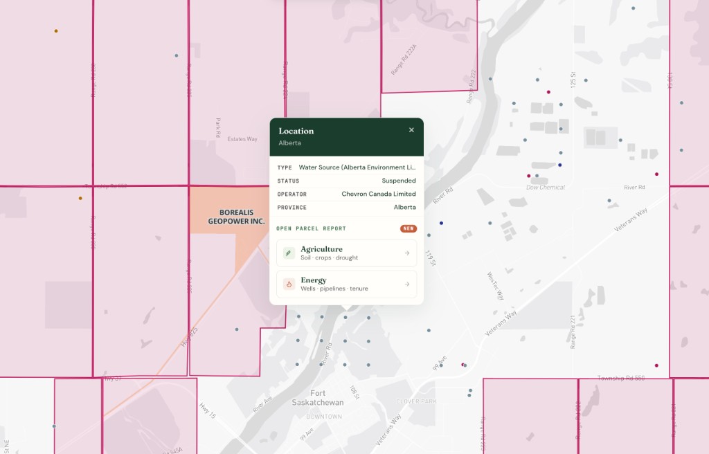
Township Canada's CCS Tenure Layer displays AER-licensed subsurface pore space tenure zone boundaries directly on the DLS grid map. The layer is free at all tiers - no Energy Bundle required. Toggle it from the map layers panel on any paid plan.
With the CCS Tenure Layer active, you can see which quarter sections fall within a licensed tenure zone without leaving the map interface. The tenure zone boundary is overlaid on the DLS grid, so each quarter section's relationship to the boundary (fully inside, partially overlapping, or adjacent) is visible at a glance.
The practical workflow for a tenure proposal:
- Open the DLS grid map and toggle on the CCS Tenure Layer from the layers panel. The map displays all AER-licensed pore space tenure zone boundaries over the DLS survey grid.
- Navigate to the target area: search for a DLS location within your proposed tenure zone. If your geological model centres on Township 55, Range 20, West of the 4th Meridian, enter a legal land description like NE-16-055-20-W4 in the Alberta legal land description converter to centre the map on that township.
- Identify quarter sections at the boundary: zoom to the sections where the tenure zone edge intersects the DLS grid. Each quarter section (NE, NW, SE, SW) is visible as a subdivision of the section. Note which quarter sections fall inside the tenure boundary and which fall outside.
- Build your parcel list: record each quarter section that appears within or adjacent to the tenure zone. Format them in standard DLS notation: NE-16-055-20-W4, SW-17-055-20-W4, and so on.
For areas where an existing licensed tenure zone already covers the formation, the CCS Tenure Layer shows the exact boundary. You can verify whether your proposed tenure area overlaps with an existing licence, something the AER requires you to address in the application.
Batch Export: Preparing GeoJSON for AER Submission
Once you have your list of quarter sections, the next step is generating the spatial data the AER requires. CCS tenure applications include a map exhibit with the tenure boundary and all associated DLS parcels. The standard submission format is a shapefile or GeoJSON file.
For teams working from a spreadsheet of quarter section descriptions, the Business-plan batch converter and Batch API process up to 5,000 DLS descriptions in a single upload. Upload a CSV with your full list of quarter sections, and get back GPS coordinates and boundary polygons for each one. The output can be exported as GeoJSON, Shapefile, KML, or DXF, all formats the AER accepts for map submissions. The CCS pore space tenure boundaries themselves are visible on the map as a free layer at all tiers.
Here's the typical batch workflow for a CCS tenure submission:
- Prepare the CSV: one quarter section per row, formatted as standard DLS notation. Include a column header of
legal_land_description. Example rows:NE-16-055-20-W4,SW-17-055-20-W4,SE-19-055-21-W4. - Upload to the batch converter: drag and drop the CSV into the batch conversion page. The tool auto-detects the input format and processes all rows.
- Export as GeoJSON or Shapefile: download the results in the format your AER submission requires. The GeoJSON export includes point coordinates and boundary polygon geometry for each quarter section.
- Load into your GIS: import the GeoJSON or Shapefile into ArcGIS Pro, QGIS, or your project's GIS environment. Overlay the results against the geological model to confirm alignment between the DLS parcels and the formation boundary.
The batch API guide covers programmatic batch conversion for teams integrating this into an automated pipeline.
Location Data Checklist for an AER CCS Tenure Proposal
Before submitting a pore space tenure application, verify the location data against these requirements:
Pore space tenure area (subsurface)
- Every DLS section within the formation boundary is listed
- Quarter sections at the formation edge are individually enumerated (not just the section)
- Meridian designations are correct (W4 and W5 are roughly 250 km apart, and a transposition puts the entire tenure area in the wrong region)
- Township and range numbers match the geological assessment
Surface infrastructure parcels
- Injection well LSDs are specified to the legal subdivision level (e.g., SE-22-055-20-W4)
- Monitoring well locations include the LSD or quarter section
- Pipeline corridors list each quarter section the route crosses
- Compressor station and facility parcels are identified at the quarter section level
Map exhibit data
- GeoJSON or Shapefile includes boundary polygons for all tenure parcels
- Point coordinates for each parcel resolve to the correct location on satellite imagery
- The exported boundary polygon for the tenure zone matches the geological formation extent shown in the reservoir model
- No duplicate or overlapping entries in the parcel list
Cross-references
- Existing licensed tenure zones checked for overlap (the CCS Tenure Layer shows these)
- Surface rights confirmed against Alberta Land Titles
- Adjacent mineral rights holders identified where required by the AER
A meridian transposition (listing W5 instead of W4) shifts an entire section roughly 250 km west. For the Fort Saskatchewan-Heartland example, that error moves the tenure area from the Edmonton industrial corridor to the foothills near Edson. The AER will reject it, but catching it before submission saves weeks of review delay. The batch converter's processing report flags descriptions that don't resolve to expected coordinates, which catches these errors before they reach the AER.
From Formation Boundary to Filed Application
CCS pore space tenure proposals require a level of DLS precision that most conventional oil and gas filings don't. A standard well licence references one LSD. A CCS tenure application references dozens of sections and hundreds of quarter sections, with the formation boundary cutting through sections at angles the DLS grid wasn't designed for.
The combination of the CCS Tenure Layer for visual identification and the batch converter for spatial data export covers the two parts of this workflow that consume the most time: figuring out which quarter sections are in the tenure zone, and generating the GeoJSON the AER needs in the submission.
If your team is preparing a CCS tenure proposal ahead of the June 30, 2026 deadline, the CCS Tenure Layer is free at all tiers; the Batch API and batch converter are Business-plan features. The batch converter handles the full parcel list in a single upload. For an overview of how DLS legal land descriptions work across all CCS tenure components (surface, subsurface, and infrastructure), see the carbon sequestration industry guide.